


En Español

Watershed 101

What is a Watershed?
How Does a Watershed Work?
When Does the Water Flow?
How Does a Watershed Function?
Why Are Riparian Wetlands Important?
What is Groundwater?

What is a Watershed?

A watershed, also called a drainage basin, is an area that contributes surface water and groundwater to a specific stream. All land is part of some watershed. Wherever you go, you are in a watershed. A watershed is bounded in all directions (except down valley) by a drainage divide, which is the line of separation between runoff that descends in the direction of the watershed in question and that which goes toward an adjacent watershed.

The watershed for a principal river like the Rio Grande encompasses the smaller drainage basins of all of its tributaries. The major tributaries of the 1,825-mile, 3,042 kilometer Rio Grande are the Pecos River in Texas and the Rio Conchos in Chihuahua. In all, the Rio Grande watershed encompasses 335,000 square miles, or 862,500 square kilometers, equal in size to 11 percent of the continental United States. The Rio Grande watershed is the darkened area in this map.


How Does A Watershed Work?

The complex system of streams within a watershed is referred to as the drainage net. In every drainage net, small streams join or come together to form successively larger ones. Little streams join bigger streams, and small valleys join more extensive ones. This relationship, although variable in detail, holds true for watersheds of any size or extent. This systematic characteristic makes it possible to recognize a natural organization within a drainage net, and the concept of stream order has been devised to describe the arrangement.

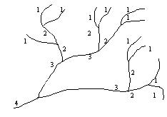
A first order stream is the smallest unit in the system and is thus conceptualized as a stream without tributaries because it represents the smallest tributary in the net. Where two first-order streams unite, a second-order stream is formed. At the confluence of two second-order streams, a third-order stream begins, and this uniting principle applies through successively higher orders in the hierarchy. The joining of a lower-order stream with a higher-order stream does not increase the order below that junction; for example, the confluence of a first-order stream with a second-order stream does not produce a third-order stream. A third-order stream is formed only by the joining of two second-order streams.

In the diagram, the steep, small segments are designated as 1 (or "first order"). Note that "stream order" in a drainage network is not determined by the presence or absence of flowing water, but by the shape of the land surface, which determines where flow will be concentrated when water is present.

In a well-developed watershed, one can predict with some certainty that first-order streams and valleys will be more numerous than all others combined and that each succeeding higher order will be represented by significantly fewer streams. Other predictable relationships include that: (1) the average length of streams increases regularly with increased order, (2) the average watershed area drained by streams increases regularly with increased order, and (3) the average gradient of streams decreases with increased order.


When Does The Water Flow?

Many of the world's streams do not flow year-round. In humid regions, streams and most tributaries are permanent, or perennial. In less well-watered regions many of the major streams and most tributaries carry water only part of the time, during the "wet season" or during and immediately after rains. These impermanent flows are called ephemeral if they carry water only during and immediately after a rain, or intermittent if they flow for only part of the year, although the term intermittent is sometimes used to apply to both cases. In desert areas, virtually all streams may be intermittent or ephemeral, with the notable exception of those that flow into the desert, bringing their water from somewhere else. These are called exotic streams.


How Does A Watershed Function?

Healthy watersheds provide three major functions. First, they transport and store water, sediment, pollutants, and organisms. In general, a stream's load consists of three kinds of materials: dissolved materials carried in solution, fine particles held in suspension, and heavier or coarser materials pushed or bounced along the channel bottom. Second, watersheds cycle and transform energy, as well as carbon, nitrogen, and phosphorus. And finally, they provide ecological succession through changes in vegetation due to movement of a watershed's energy, water, and materials from abiotic environment to biotic. The drainage net of a watershed provides habitats for aquatic organisms, is an important component of terrestrial ecosystems, and conveys runoff and sediment loads out of each stream's watershed.

Over time, a stream becomes graded. That is, a balance or equilibrium is reached among channel slope (gradient), channel characteristics, available discharge, and load. Stream banks and channels are relatively stable under graded conditions. This balance is upset, however, by changes to the land cover and surface characteristics of the watershed.

The urbanization of watersheds increases the imperviousness of land surfaces, alters the density of channels, and diverts much of the surface drainage to underground storm sewers. This, in turn, dramatically changes the volume of water and the amount and type of material that streams in urbanized watersheds convey. Urbanization also alters the physical configuration and stability of stream channels, reducing their value as wildlife habitats.


Why Are Riparian Wetlands Important?

Riparian wetlands are found in low-lying regions adjacent to rivers and streams that are periodically subjected to overbank flooding. Since they are hydrologically connected to both the river (downstream) and surrounding watershed (upstream), riparian wetlands are of major importance in the watershed system. Riparian wetlands intercept surface and subsurface (groundwater) runoff from the upland regions of the wetland and thus function as buffers for the river systems. These wetlands also interact periodically with floodwaters originating from rivers and streams; these hydrologic interactions can have a significant effect on river water quality.

Riparian wetlands have been shown to be highly effective in the reduction of non-point source (NPS) loading of nutrients and sediments to rivers and streams. As a result, many agricultural (including forestry) Best Management Practices (BMPs) are based on the premise that riparian buffer zones, which include wetlands and non-wetland areas, are essential components of the watershed that should be preserved or restored. Of particular significance to downstream water quality are riparian wetlands associated with low-order (smaller) streams, because of the large hydrologic throughput in these wetlands relative to the flow in the river or stream. These wetlands generally occur in the upper reaches of watersheds. Although the riparian zone of a single low-order stream may seem insignificant to water quality in the watershed, the cumulative impact of the multitude of riparian wetlands along low-order streams can be extremely significant.

What is Groundwater?

Some precipitation infiltrates the ground and fills the pores in soil and rock. The subsurface area where all available soil and rock spaces are filled by water is called the zone of saturation, and the water in these pores is called groundwater. The water table is the upper surface of the zone of saturation. It is the fuzzy and fluctuating dividing line between saturated soil and rock, where every available pore is full, and unsaturated (but still wet) rock and soil where the pores can absorb more water. The water table falls in dry weather and rises in wet weather.

The ability of soil or rock to hold water depends on its porosity and permeability. Porous, water-saturated layers of sand, gravel, or bed rock through which groundwater flows and that can yield an economically significant amount of water are called aquifers.

Click for enlarged image

Click for enlarged image

In parts of Texas, more groundwater is being used than is being replenished through natural means. If this practice continues, Texas water costs will rise, land could subside, water quality could decline and people in some areas could run out of water. To address this problem, the Texas Legislature has provided a way for groundwater resources to be managed and protected locally, through the creation of groundwater conservation districts.